Hurricane Melissa: Why Jamaica Faces a 'Catastrophic' Slow-Motion Disaster
Hurricane Melissa brings unprecedented danger to Jamaica with 40 inches of rain and sustained 175 mph winds. Learn why its slow movement makes it more devastating than faster hurricanes and what this means for affected communities.
Forty inches of rain is about to hit Jamaica. Let that sink in—that’s taller than your average 4-year-old child. Hurricane Melissa has just become the strongest storm ever recorded to hit Jamaica, and what makes it deadly isn’t what most people typically associate with hurricane danger.
While media attention often focuses on wind speeds and storm categories, meteorologists are increasingly concerned about a different factor that makes Melissa particularly devastating: its painfully slow movement.
The Deadly Crawl: Why Slow Hurricanes Are More Dangerous
Hurricane Melissa is currently moving at just 2 miles per hour—literally walking speed. This seemingly innocuous detail actually transforms the storm from dangerous to catastrophic.
When hurricanes move quickly, they dump their rain and leave. It’s like nature’s version of a hit-and-run. But Melissa is essentially parking over Jamaica for days, creating what experts call a “prolonged impact event.”
To put this in perspective: Imagine standing under a fire hose for 10 minutes versus 10 hours. That’s the difference between a fast-moving hurricane and Melissa’s lingering devastation.
This means places like Kingston will experience catastrophic winds for 12+ hours straight—conditions that few structures are designed to withstand. The sustained battering breaks down even well-constructed buildings over time.
Inside the Monster: What Hurricane Hunters Discovered
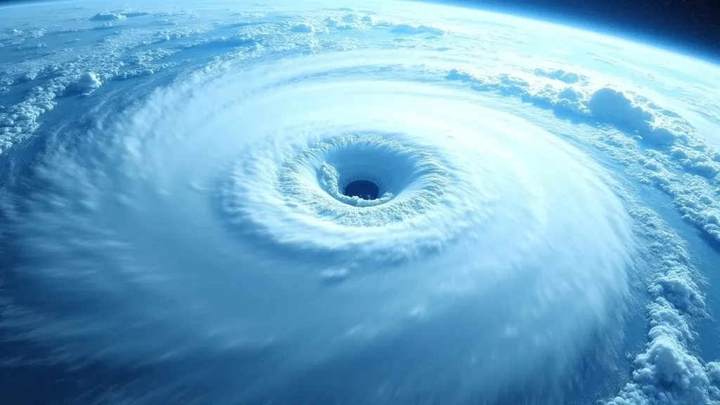
The satellite imagery of Melissa reveals a perfect, well-defined eye—a sign of extreme organization and strength. So extreme, in fact, that hurricane hunters—professional storm chasers who fly INSIDE hurricanes for data collection—had to abort their mission due to extreme turbulence.
Let that sink in. The professionals who fly into storms for a living deemed Melissa too dangerous to approach.
Jamaica’s Geography: A Dangerous Amplifier
What many weather reports fail to explain is how Jamaica’s topography will actually intensify the storm’s effects. The island’s mountainous terrain creates a dangerous amplification effect.
Wind speeds increase by approximately 30% at higher elevations, turning the already catastrophic 175mph winds into 227mph gusts—strong enough to lift concrete and completely destroy reinforced structures.
The Critical Differences in Wind Damage
- At 175mph: Entire roofs are torn off buildings
- At 227mph: Entire buildings collapse
Compounding this danger, the ground is already saturated from October’s previous rainfall, creating ideal conditions for widespread landslides that could wipe out entire communities perched on hillsides.
On the Ground Reality: Communities Already Cut Off
“We can’t move. We’re scared,” reported one local resident before communication systems began failing. Some communities are already completely isolated by impassable roads—and the hurricane hasn’t even made landfall yet.
The Prime Minister’s warning was unusually blunt: “I don’t believe there is any infrastructure within this region that could withstand a Category 5 storm.”
This isn’t hyperbole—it’s a recognition of the unprecedented nature of what’s unfolding.
The Broader Impact: A Multi-Nation Disaster
Three people have already died in Jamaica, with four more fatalities reported in Haiti and the Dominican Republic. By the time Melissa completes its destructive path, it will have affected at least five countries, including Cuba and the Bahamas next.
This makes coordinated disaster response even more challenging, as regional resources are stretched across multiple affected areas simultaneously.
The Reality Behind the Numbers
Statistics about hurricanes can sometimes feel abstract. So let’s make this concrete: 40 inches of rain isn’t just a number—it’s the height of your refrigerator, about to fall from the sky.
That volume of water, combined with sustained Category 5 winds and mountainous terrain, creates conditions that meteorologists classify as a “catastrophic event”—a term not used lightly in professional weather forecasting.
What Happens Next
As Melissa continues its slow crawl through the Caribbean, emergency management officials are already preparing for what could be one of the most significant recovery efforts in the region’s recent history.
For those with connections to affected areas, now is the time to check on loved ones, as communication infrastructure will likely be compromised for days or possibly weeks.
Staying Informed
As the situation develops, reliable sources for updates include:
- The National Hurricane Center (nhc.noaa.gov)
- The Jamaican Meteorological Service
- International aid organizations like the Red Cross
This slow-moving catastrophe serves as a powerful reminder of nature’s force and the complex factors that contribute to hurricane danger beyond simple wind speed classifications.
Our thoughts are with all those affected by Hurricane Melissa. We’ll continue to provide updates as this situation develops.